Friday, September 23, 2016

Don River Murals


Toronto’s Love Letter Project is a group of murals painted on some of the support pillars for the on- and off-ramps connecting the Don Valley Parkway to the Gardiner Expressway. These ramps cross over the mouth of the Don River just north of where it turns 90 degrees to the west and becomes the Keating Channel.

The murals can be reached on bike from the east by using the Lake Shore East Recreational Trail. It can be reached from the north or west by using the Lower Don River Trail.

To me, the theme of the murals is what the Don River once was and what it could be again. They are a project of the PangeaSeed Foundation.


↑ The southernmost pillar is the tallest. This pillar has the river’s current name as well as its former name. The river was known to the Mississaugas as the Wonscotonach. It was renamed in the 1790s by John Graves Simcoe, who was then the Lieutenant-Governor of Upper Canada.


↑ This mural is by Kirsten McCrea.


↑ This mural is by PA System.


↑ This mural is by MC Baldasarri.


↑ This mural is by EGR.


↑ This mural is by Rajni Perera.

All photographs by Rob Tilley

Sources:
A Love Letter to the Great Lakes
Discover the Don
The Wonscotonach River
John Graves Simcoe

Monday, October 26, 2015

Building T—Pumping Station


North of Toronto’s Lake Shore Blvd. E., a little west of Coxwell Ave., is a building I’ve always considered a fascinating landmark. This round structure is the blandly named Building T. Viewed from the south, it stands out, majestically in my view, on a field, looking something like a sci-fi version of a medieval keep.


↑ Building T can be reached using a bicycle path called Route 4 West (which parallels the Lower Don Recreation Trail). Route 4 West is on the north side of Lake Shore Blvd., south across the field from Building T.


↑ To the southeast of Building T is Beach Skateboard Park. I was there on a weekday, when there was only one skater. On weekends or after school hours, this park can be a busy place.


↑ I picked up a few burrs walking through the above area. It was a lovely late morning, about 10° C out, and not a cloud in the sky.


Formerly known as the Mid-Toronto Interceptor Pumping Station, Building T was designed in 1971 by Gore & Storrie Limited (now known as CH2M HILL), an engineering firm. (Another of their projects was Toronto’s famous R.C. Harris Water Treatment Plant, designed and constructed in tandem with H.G. Acres Limited between 1932 and 1941.)

↑ Building T is notable for its catenary arches. The exterior is made of concrete, stone, and aluminum.


↑ Building T was not the first pumping station on the site. That was Building M—or as it is called on the building itself, Main Drainage Pumping Station. Building M was constructed in 1911.


Buildings M and T service Ashbridges Bay Wastewater Treatment Plant. Construction on the plant began in 1908. At the time it was Toronto’s only municipal sewage treatment facility and remained so until 1926. Some of this facility’s buildings can be seen in the above view, looking south from near Building T.

Click here to see an excellent overhead drawing of the treatment plant and M and T buildings.


↑ Another view looking south. The Ashbridges Bay Wastewater Treatment Plant’s stack and water tower can be seen in the far distance between the west side of Building M (left) and Building T (right).


↑ Seen from below, Building T is a striking sight. I had to get within a metre or two of it before I noticed an unpleasant odour.


↑ These light fixtures ring the building.


↑ The Tubs and Gee Gage Rugby Field lies to the southwest.


All photographs by Rob Tilley

Sources:
1091 Eastern Avenue – Inclusion on Heritage Inventory
Ashbridges Bay Treatment Plant Pumping Stations (1911 and 1971)
CH2M HILL
Ashbridges Bay Wastewater Treatment Plant
Odour Control at Ashbridges Bay

Thursday, September 3, 2015

The Mouth of the Don River


Well, actually, Toronto’s Don River really doesn’t have a mouth. At its southern end the river makes a 90 degree turn and becomes the Keating Channel, which then lets into the Inner Harbour 750 metres to the west. In the above image, the lower bridge carries Lake Shore Boulevard East while the eastern end of the Gardiner Expressway lies above. Keating Channel is just beyond.

This area just north of Keating Channel is a very busy place. Here, the Don is crossed by a footbridge (on which I stood to take the above photo), another bridge supporting both Lake Shore Boulevard and a railway track, and the ramps connecting the Gardiner Expressway to the Don Valley Parkway and to Lake Shore Boulevard. This is truly an urban river scene.

The water of the Don is heavily polluted and looks it. But much effort has gone into restoring the river. In 1989, the Task Force to Bring Back the Don was created; and since then, wetlands along the river have been restored and hundreds of thousands of plants and trees have been planted. Pollution levels in the river have been reduced and restorative work continues. However, the Don remains one of Canada’s dirtiest rivers.


↑ I felt sorry for these two ducks swimming in the river.

This area of the Don River can be reached in pleasant fashion by bicycle. The Lake Shore East Recreational Trail follows Lake Shore Boulevard from Coxwell Avenue to the Don River. The Lower Don Recreational Trail follows the Don River south from Overlea Boulevard to Lake Shore Boulevard, where it hooks briefly westward, ending at Parliament Street.


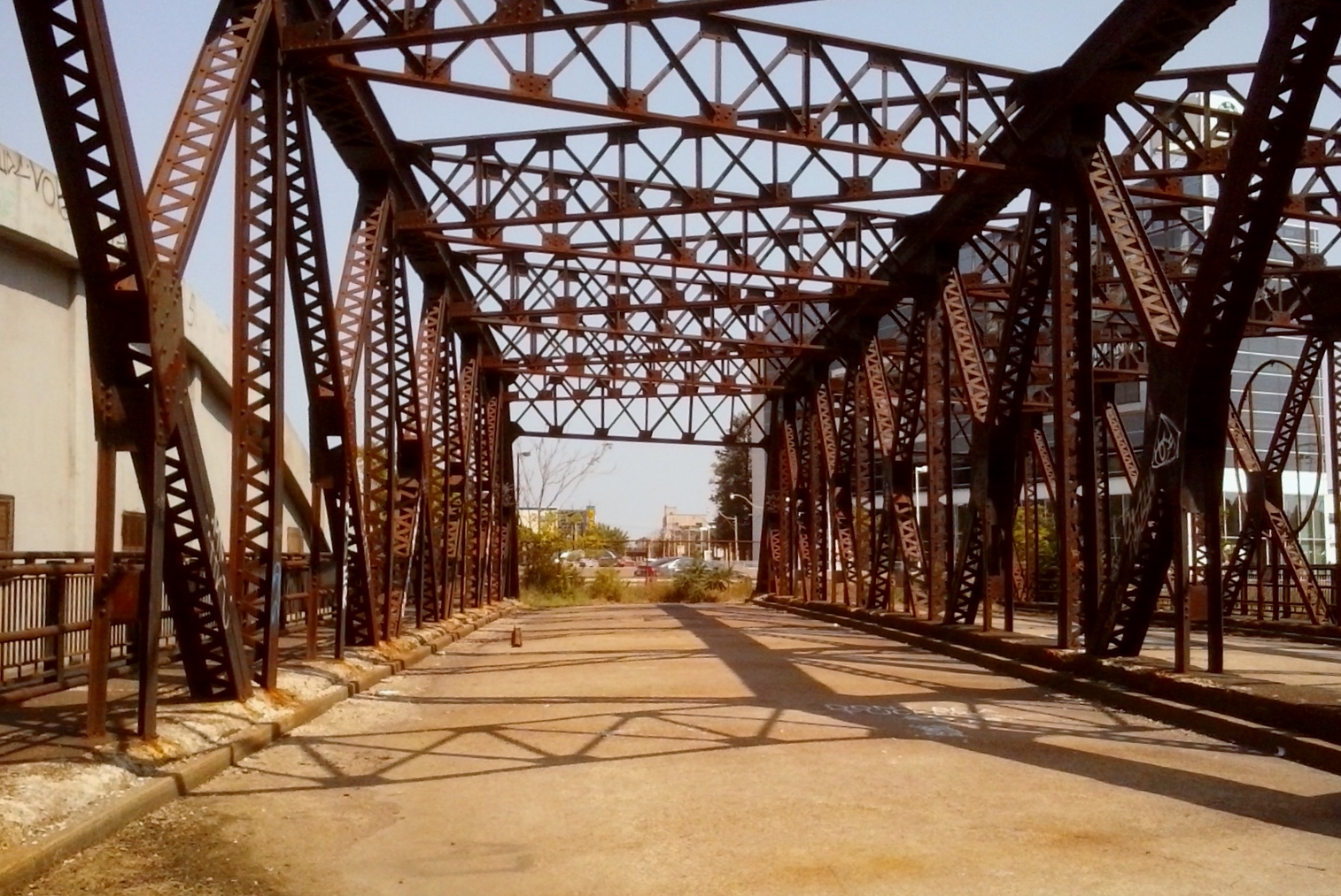
↑ This railway track crosses the river just to the north of Lake Shore Boulevard. The on-ramp to the Gardiner Expressway can be seen at the top right.


↑ Looking west from the east side of the river.


↑ Looking east from the west side of the river.


↑ Looking southwest from the footbridge.


↑ Looking northeast to the footbridge.


↑ Looking north from the footbridge. These are the ramps connecting the Don Valley Parkway to the Gardiner Expressway.


↑ The bike path west of the footbridge.


↑ Under the on-ramp to the Don Valley Parkway. This is just west of the river.


↑ On the right is the on-ramp to the Don Valley Parkway. This ramp, although it looks a bit like a long slide, is not nearly as fun as a slide...


↑ Looking to the footbridge from the west side of the river. You wouldn't want to swim, fish, or picnic here, but the area certainly has many impressive sights.

All photos by Rob Tilley.

Sources:

Ford, Ray – “Death and Rebirth on the Don River”
Wikipedia – “Don River (Ontario)”
City of Toronto – “The Don River and Central Waterfront Project: Cleaning Up Our Waterways"

Saturday, August 29, 2015

Old Eastern Avenue Bridge


Cyclists who bike the Don River trail in Toronto will be familiar with the forlorn sight of this abandoned, fenced-off bridge that crosses the river just south of Eastern Ave.

Made of steel and concrete, the bridge is 45 metres long and 19 metres wide. The Old Eastern Avenue Bridge, as it is called, was built in 1933. It replaced a bridge that had been wrecked during the spring thaw of that year.


The bridge once joined Sunlight Park Road, which meets Eastern Ave. about 300 metres to the east. It was closed in 1964 after the construction of a new bridge just to the north removed the need for the old one. Eastern Ave. had been rerouted to the new bridge at that time because of the construction of the Gardiner Expressway–to–Bloor St. section of the Don Valley Parkway.

Because it was cheaper to leave the bridge in place than to remove it, the bridge was left intact. It is still periodically inspected by the city.


↑ The concrete arch that runs beside the old bridge on its north side supports a large gas main. This arch was built for Consumers’ Gas (later Enbridge) in 1930. It is also 45 metres long and is not a pedestrian bridge.

While I was near the bridge, I saw what I thought was a groundhog. I hope the groundhog doesn’t rely on the river for water. The water is none too clean…


↑ Looking south along the Don River. The Don Valley Parkway is on the left.


↑ The bridge ends at the Don Valley Parkway now.


↑ Looking north. The concrete arch carrying the gas main can be seen.

All photos by Rob Tilley.

Sources:

Bateman, Chris – “A Brief History of Crossing the Don River”
Brown, Edward – “Ask Torontoist: A Grey Bridge To Nowhere”
HistoricBridges.org – "Eastern Avenue Bridge"
Wikipedia – "Old Eastern Avenue Bridge"

Thursday, August 13, 2015

Cycling Chaos

More cycling follies. This time I watched as a cyclist who was approaching an intersection saw an opportunity to make an early left and took it. Instead of making his left at the intersection, he abruptly crossed to the other side of the road several car lengths before arriving at the intersection. He proceeded to ride against traffic on the wrong side of the road and then cross in front of the path of a driver who was about to turn right. Once past the surprised driver, the cyclist finally made his left.

In Toronto, many cyclists follow the traffic rules only when it is convenient or when they have no choice; i.e., when traffic is so heavy it would be impossible to do anything but follow the rules. I still see many almost daily examples of such make-it-up-as-you-go-along cycling.

Many cities in the world have looser approaches to traffic rules. Ho Chi Minh City is such a place. This short video made by Rob Whitworth shows some excellent examples of the wild traffic in this Vietnamese city.

My feeling is that it is more pleasant to observe such traffic from a bird’s-eye view than it is to take part in it at ground level. Unlike in Ho Chi Minh City, in Toronto cyclists are still in the minority of road users. While Whitworth’s video show traffic moving fairly easily, I don’t think this kind of functional chaos could be successfully transplanted to Toronto’s car and truck–dominated roads.

Toronto traffic is not yet Ho Chi Minh City traffic. In Toronto, traffic proceeds in a—usually—orderly fashion. Drivers and pedestrians still expect their fellow road users to follow the rules. As Toronto's population grows, chaos on the roads will increase everyone’s travel times and make their trips more dangerous and stressful.

Thursday, August 6, 2015

Cyclist to Pedestrian and Back Again

One neat trick I often see cyclists perform is the instant transformation from cyclist to pedestrian. This often happens when a cyclist reaches a red light and then turns left into the pedestrian crossing area in order to get to the other side of the street. If cyclists dismount and walk their bikes across the street, I don’t see a problem. But I more commonly see them remain on their bikes as they turn into the pedestrian area.

This is a dangerous manoeuvre. Pedestrians are not expecting cyclists to do it; nor are drivers. I’ve seen cyclists swerve into walkways at a fair clip, then weave among the startled pedestrians. There is a good chance of running into someone this way. And what of the driver at the intersection who is about to turn right? This driver will expect a cyclist to stop, not abruptly cut into the car’s path.

Another sudden cyclist-to-pedestrian-and-back transformation occurs when cyclists approach red lights at three-way intersections. If the sidewalk is on their right, some cyclists will jump to the sidewalk, bike past the intersection, and then jump back to the road. I imagine this must be very irritating to the drivers (and cyclists) who are patiently waiting for the light to change. I think cyclists, if they are not going to wait for a green light, should not bother with the pretense of biking onto the sidewalk. No one buys their bogus cover act of “Hey, look! Suddenly I’m a pedestrian—and suddenly I’m not!” They might as well just own what they are doing and bike through the red light.

Cyclists in Toronto still have a reputation for ignoring traffic rules. Pedestrians and drivers alike regularly complain about this. I feel the situation has improved in recent years, but cyclists’ reputation for road-warrior like behaviour is still well deserved.

Friday, April 10, 2015

Transporting Children on Bikes

Riding a bicycle in the city can be a dangerous activity. Not hugely dangerous, but definitely somewhat dangerous. There is no doubt about it. You have to be smart and cautious to avoid being a statistic. But cyclists, for the most part, are only risking themselves. In a typical collision, the cyclist may be badly injured or killed and the bike wrecked, but the driver will usually be uninjured while the car ends up with only a few dents or scratches.

Every once in a while, though, I’ll see cyclists risking not only their own lives, but their children’s too.

The other day as I walked down Woodbine Road in Toronto, I saw a woman and her young child bomb by on a bike. It’s hard to say how old the child was because the bike flashed by me at such high speed. The child was behind the woman, held in a rear-mounted child seat. Woodbine is a major, four-lane road. At the time of day when the woman and her child passed me, traffic is fairly light on this road and, therefore, cars and trucks sometimes travel at fairly high speed. Moments after the bike went by I saw a truck rocket by at what must have been 60 kmh or more. This truck would have passed the woman and her child moments later, very likely in the same lane.

Believe me, I’m all for people using their bikes in town, but I feel that if you want to take your kid with you, either on a bike seat or in a trailer, you really should keep to bike paths and side streets. If you have to cross a major street, dismount and briefly become a pedestrian.

I do have to point out that what I am saying in this post is based on a gut reaction. I was unable to find any numbers for crashes, injuries, or deaths involving children riding in bike seats. An article in The Boston Globe dated May 24, 2014, says: “Statistics about the dangers of biking with children are hard to find. No health or safety agency has information broken down that way.”

I also wondered which of the two methods of transporting young children on bikes was safer. Every source I found said that trailers were safer than rear- or front-mounted child seats. Please note, though, that it is very important to have a high-flying orange flag attached to a trailer to make it more visible to drivers.

An article posted by Parachute reported, “bike trailers are considered somewhat safer because children are lower to the ground and have less of a distance to fall in a crash.”

ConsumersReports.org had this to say: “trailers can tip over if you turn abruptly or turn when one wheel is going over a bump.” But they went on to say that bicycle trailers provide “some protection to passengers since kids are seated, strapped in, and usually enclosed in a zippered compartment. Trailers have a rigid frame enclosed in durable fabric, which offers some protection for young passengers if the unit rolls over”

The American Academy of Pediatrics says that “preferably, children should ride in a bicycle-towed child trailer.”

Please consult the web pages I mentioned for detailed safety instructions on using bike trailers.